Ruby Redemption: Skiing Ruby Mountain in the North Cascades

DATE HIKED: 4/17/22
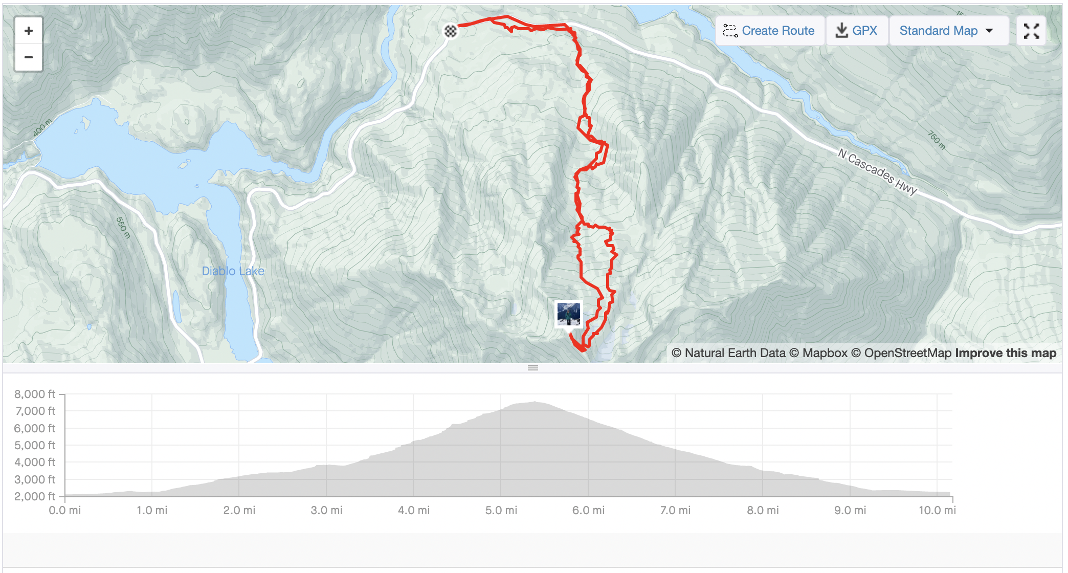
TOTAL MILEAGE: 10 MILES
TOTAL ELEVATION GAIN: 5,700’
RED TAPE: National parks pass is required to park at the trailhead. Camping is allowed with overnight permits from North Cascade National Park.
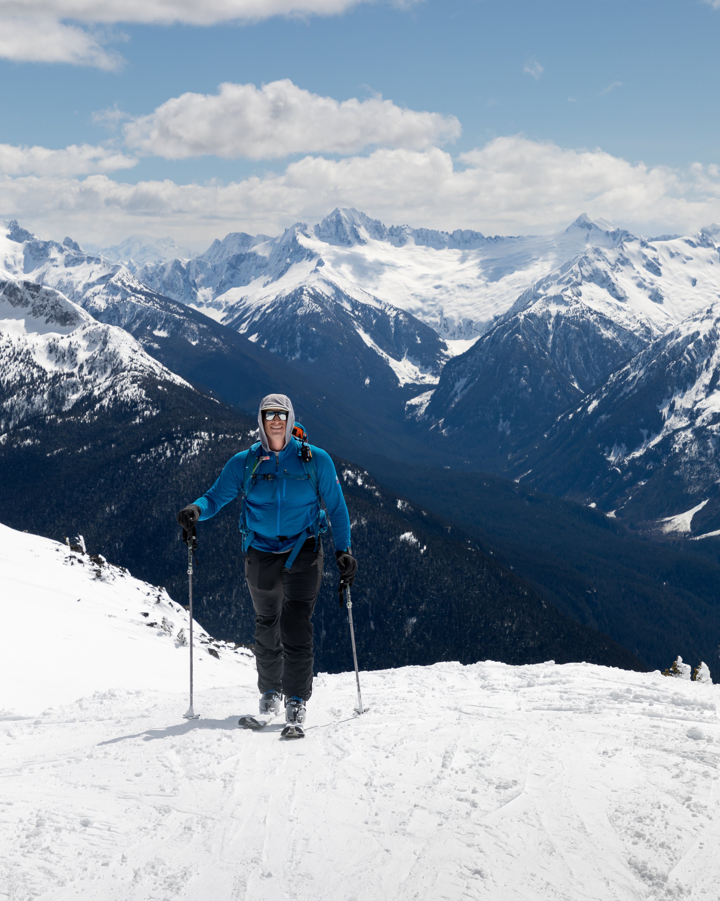
If you’ve been reading my blog for awhile you may have noticed that trips and adventures don’t always go as planned and sometimes objectives require multiple attempts before we’re successful. This was the case for Ruby Mountain in the North Cascades. In May of 2021, Alex and I started our tour at the Happy Creek trailhead bright-eyed and bushy-tailed. We knew the day ahead of us would be arduous but we felt we were adequately prepared both mentally and physically. It turns out we were wrong. After about 1.5 miles the Happy Creek trail ends and hikers hoping to make their way to Ruby Mountain have to navigate a “climber’s path” that is sometimes indistinguishable from the foliage and duff around it. This makes it incredibly easy get lost. Alex and I wallowed in the forest for over an hour and had little to no progress to show for our time. Without an established path we constantly second-guessed our route selection and routinely had to pull out our GPS to ensure we were headed the right way. Eventually we were too frustrated to continue. We fell well behind our timeline for the day so we turned around. Our once bushy tails drooped figuratively between our legs as we made our way back to the trailhead, dejected.
We vowed to return again in 2022, earlier in the season so instead of contending with a dry forest ground where paths grow obscure, we could hopefully follow in the well-trodden and snowy footsteps of previous climbers.
A weekend in mid-April looked promising—a fresh dusting of snow, low avalanche conditions, and intermittent clouds. We called up our friend Nate and asked if he’d like to join and a date was set. Sunday, April 17 would be our Ruby redemption attempt!

Highway 20 was still closed for the season but thankfully the gate (and the Ross Dam Trailhead) is only a tenth of a mile from the true starting point at Happy Creek Trailhead. Wanting to allot ourselves ample time in case there were any navigation issues, we arrived at the trailhead just before 8AM and found the lot almost full. It appeared that many people shared our sentiment that it would be the perfect spring ski day.
After loading our skis and packs onto our backs we hit the pavement. Our plan for the day would take us back to the Happy Creek Trailhead, along the established path and then into the forest that we were lost in just 11 months prior. I was already apprehensive about the prospect of a second failed attempt but tried to keep my spirits up as we plodded along.
The snow line was much lower in mid-April than it was in mid-May and by the time we reached the climber’s trail there was sufficient snow cover and the footprints of a parking lot full of people left route-finding a piece of cake. I checked our path from the previous year and had to shake my head and laugh when I saw the tentative approach we had taken last year—the one we so often second-guessed—was smack dab on top of the “trail.” We were in the right place the whole time!
Unfortunately, while the route-finding may have been easier than the year prior the route itself was still tricky. We found ourselves in what we, and most other people we talked to, dubbed “Bullshit Forest.” It was some of the most atrocious skinning I have ever encountered. The skin track was icy and there was little rhyme or reason as it meandered along; it would descend 40 feet only to immediately gain another 50 feet, it went right over fallen trees instead of around, and it continued like this endlessly. Yes, we could have tried to create our own route, but it was much easier to follow an already established trail than attempting to forge our own even if that established route was less than ideal.

Finally, the canopy above us allowed more and more light to filter through until the trees cleared altogether and we popped out of the forest and into a clearing that gave us our first real views of the day. Looming ahead of us was the massive face of Ruby Mountain. It towered. It looked like it was still thousands of feet above us—and it was! We still had over 3,000’ of climbing ahead of us. Seeing our objective was both demoralizing and motivating. Now that we had spied the summit, I would always be able to keep one eye on the objective and watch it slowly lower in relation to us as we gained elevation.
Behind us the views were even more encouraging. Ross Lake appeared like a blue serpent among snow-covered mountains. Hozomeen Mountain dominated the northern horizon. This is the quintessential view of any Ruby Mountain trip and I had been dreaming of seeing it for so long. We threw our packs down and took our first long break.
Properly satiated with snacks and photos we continued onward and upward. Before we could break out of the trees for good, however, we had to enter one most forest: Bullshit Forest 2.0. But, toiling in the forests was worth it. Atop a ridge at 6200’ the views were continuing to grow even more astonishing, and to my pleasant surprise, the summit of Ruby Mountain appeared just a little less out of reach.

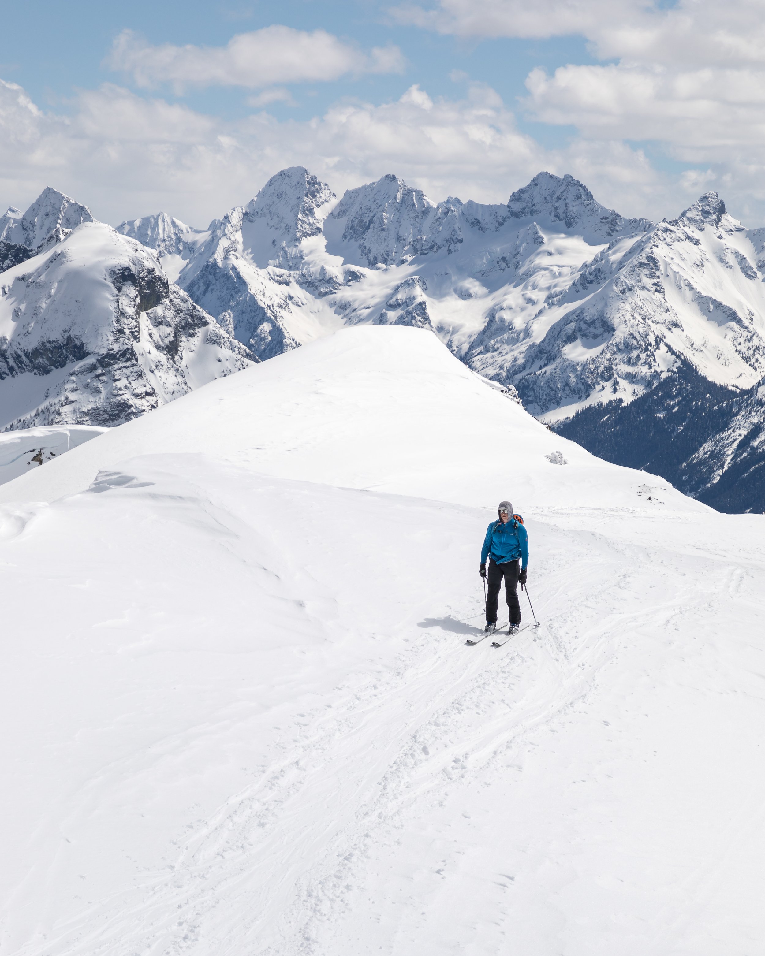
The final 1,000’ or so were the toughest. Alex, Nate, and I all settled into our own paces. I was feeling strong so I skinned on ahead, looking forward to finally being able to take an extended break on the summit. Despite all our protestations in the forests, at least they protected us from the wind. In the open the wind came in cold gusts so I alternated between too warm in the sun and too cold in the wind and my body temperature regulation was left in a confused state. Should I take off a layer? Or add a layer? I kept wondering. Ultimately, it seemed that it would be easier to bear the wind than the warmth so I powered through the chills. I kept my eyes practically glued to the summit as I climbed.

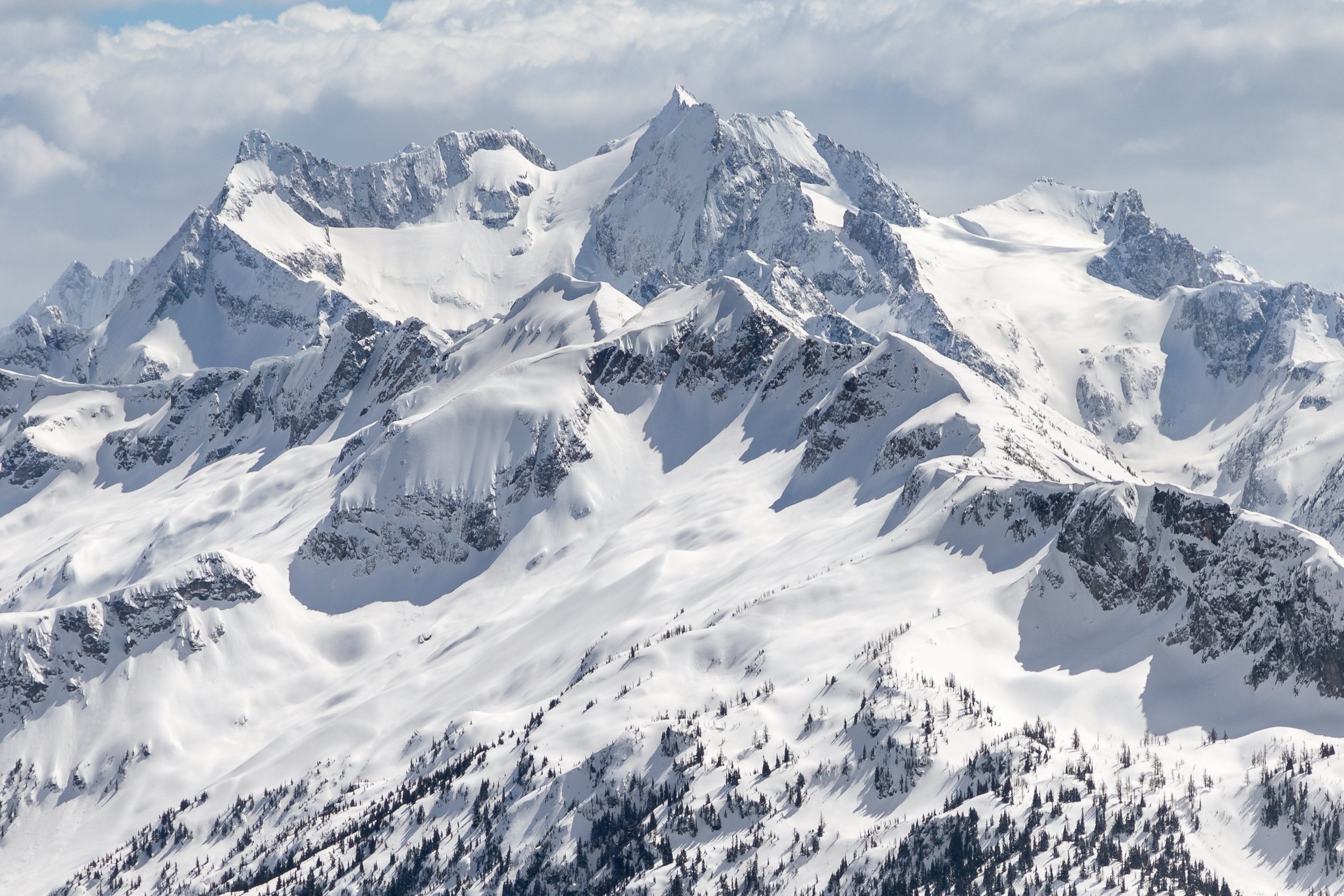
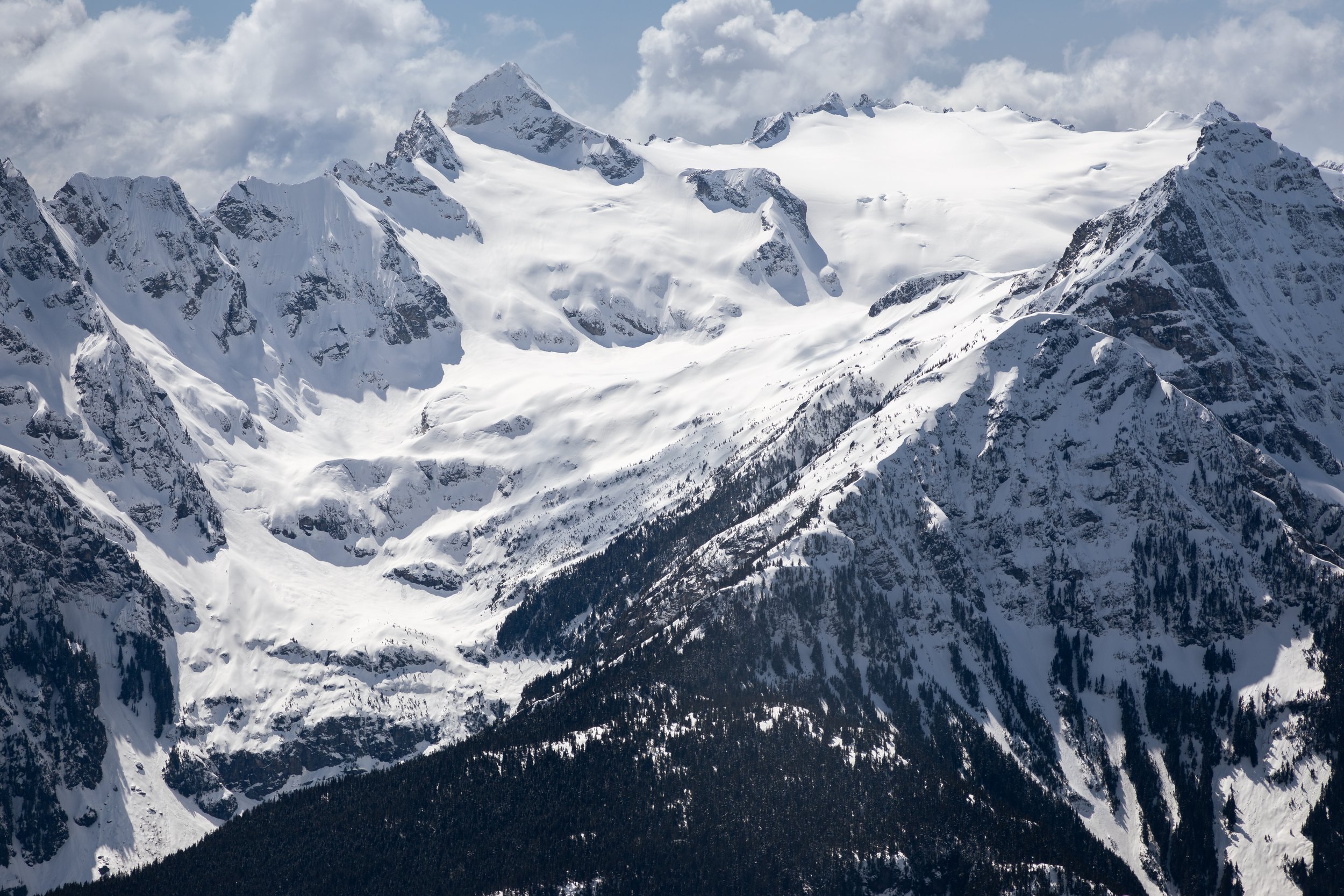
At long last I crested a ridge. From there it would be just a few more minutes of skinning along an easy ramp that led to the summit, but I had to pause on the ridge before continuing on because the views blew me away. We had spent hours with the spectacular view of Ross Lake behind us, but the views to the south and southwest were breathtaking. What felt like the entirety of the North Cascades sprawled before me in a sea of peaks, complete with jagged snow-covered summits appearing like frozen whitecaps. We could see some of the most famous and recognizable peaks of the range like Sahale, Eldorado, Snowfield, and Paul Bunyan’s Stump. The climb was arduous, to be sure, but standing atop the summit of Ruby Mountain and taking in 360 degrees of Cascades was well worth the climb and the nearly year long wait for our second attempt.
After enjoying the views from the summit and a refueling lunch it was time for the real fun to begin: The ski descent. The first few thousand feet were glorious—six inches of fresh snow that skied like butter with distractingly beautiful views to boot. Then we hit that heavy, wet, chunky snow known as Cascade concrete. Turning on tired legs was a chore. The snow did not want to give and every single turn was a fight, but eventually we made it back into the forest where a nice luge took us all the way to the snow line. We stopped and put our skis on our backs for the final hike out.
After just under nine hours we were back at the trailhead with smiles spreading from ear to ear. Ruby Mountain was everything I had hoped it would be and more. Between the views and the skiing it was the perfect spring ski tour and one I would repeat in the future. And I definitely hope to!